
Spatial Manager™ for BricsCAD
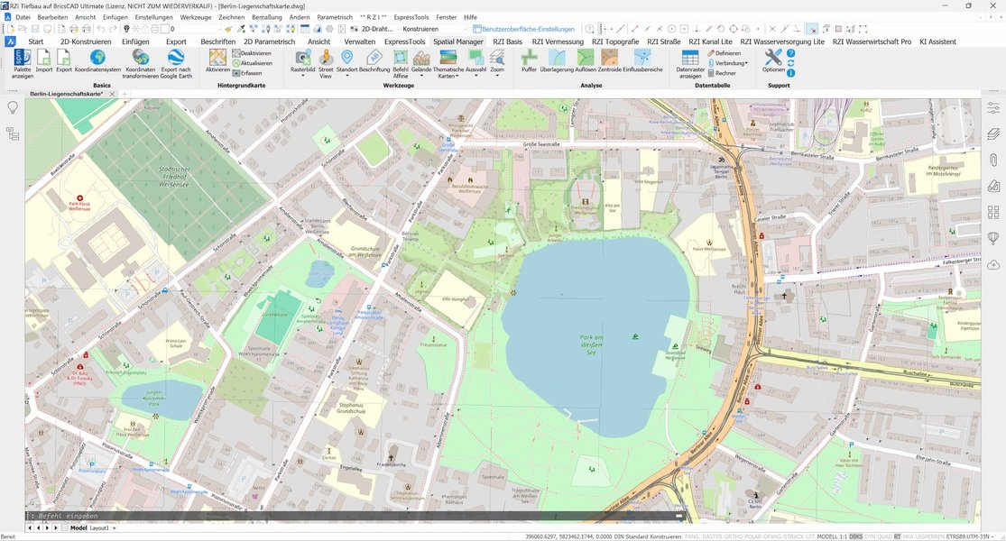
The Spatial Manager™ is, among other things, a BricsCAD plug-in that can be used to import, export, convert and manage geodata such as satellite images or ESRI data (e.g. shape) directly in CAD. This geodata is added to the drawing as BricsCAD objects and extended entity data (EED). This enables you to use your CAD almost like a GIS system, allowing you to manage, query and edit data.
BricCAD Pro or Platinum version V13 or higher is required.
We also offer the Spatial Manager™ for AutoCAD and other systems on request.
Geodata that can be imported:
- Geo files such as *.shp and *.kml
- Geo raster files such as TIF, PNG, JPG, JPEG, TIFF
- Connection to geodata servers and geodatabases
- Connection to image map server
- Other geo data sources such as WFS data storage
Exporting data - an excerpt of the options:
Export objects from the drawing to geo files or databases. The extended entity data (EED) is saved as alphanumeric data tables.
Information that can be exported:
- Coordinates
- Length or area
- Object level
- Handle
- Height
- Attributes
- Names of the block references and their properties
- Texts and their properties
The objects are checked for export to the target format and adapted if necessary. If data is incompatible, this is displayed. If only the conversion of data is required, this is also possible without importing into a drawing.
Using maps for presentation purposes
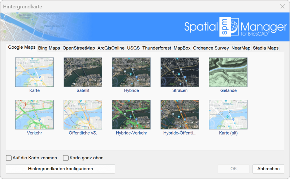
Maps can help to better contextualize projects, check plans and consolidate data bases. Use suitable background maps to present your projects more clearly or export your planning as a KML file to display it on Google Earth. You can also display geodata as a thematic map to visually highlight available information.
At the same time, maps can be used as a basis for initial rough planning. For example, an initial check can be carried out for swept paths and available areas for heavy goods transportation.
Detailed views for particularly relevant positions are possible with the integration of Google Street View.
Some advantages of the Spatial Managers™ at a glance

-
Seamless integration: This software has been seamlessly integrated into BricsCAD to enable the efficient use of geodata within your CAD environment. No more tedious conversions or compatibility issues - work smoothly with GIS data in your familiar BricsCAD interface..
-
Versatile data management: Easily import, export, edit and convert geodata in a variety of formats. Be it shapefiles, KML, GML, or DWG - Spatial Manager™ gives you the flexibility to manage your data in the format that works best for you.
-
Effective layer management: Organize your data in clearly defined layers and styles. Maintain control over complex projects by isolating and editing individual elements without affecting the overall configuration.
-
Extended functionality: This tool extends the CAD functionality with geodata functions. Use geospatial information in your design process to perform spatial analysis, visualize site data and create accurate maps.
-
Time and resource efficiency: Direct integration saves you valuable time and resources. Focus on your design without having to worry about data conversion or compatibility.

Whether you're a road designer, sewer engineer or surveyor, Spatial Manager™ is the complete solution for your geospatial and CAD needs.
List of available data providers (as of January 2024):
Geo files
- Esri Shape file - (SHP)
- Google Earth file - (KML, KMZ)
- OpenStreetMap file - (OSM, PBF, OSC) (1)
- LiDAR file - (LAS, LAZ)
- GPS exchange format file - (GPX)
- Esri ASCII Grid file - (ASC, ASCII) (1)
- ASCII text file - (ASC, CSV, NEZ, TXT, XYZ, UPT)
- SQLite file - (SQLITE, DB)
- GeoPackage file - (GPKG) (1)
- GML file - (GML, GZ, XML)
- Raster image file - (TIF, PNG, JPG, JPEG, TIFF) (1)
- Autodesk SDF file - (SDF) (3)
- MicroStation v.7 file - (DGN) (2)
- AutoCAD DXF file - (DXF) (2)
- Esri ArcInfo export file (ASCII) - (E00) (1) (2)
- MapInfo file - (TAB) (2)
- MapInfo exchange format file - (MIF/MID) (2)
- GeoJSON file - (GEO.JSON)
Geo raster files
- Raster image file - (TIF, PNG, JPG, JPEG, TIFF) (1)
- Georeference source - (World files, Google Earth .GEPRINT, etc.)
- Variable resolution raster image file - (Cloud Optimized GeoTIFF/COG TIFF) (1) (4)
Geo data servers and geodatabases
- Esri geodatabase file (1)
- PostGIS database
- Microsoft SQL Server geodatabase
- MySQL database (1) (3)
Image map server
- WMS Web Map Services (4)
- WMTS web map tile services (4)
- XYZ/TMS tile map services (4)
Other geo data sources
- Konnektivität offener Datenbanken ODBC (1)
- WFS-Datenspeicher (1)
- WFS-Datenspeicher (FDO) (1) (3) (5)
- WFS-Datenspeicher (OGR) (1) (2) (5)
(1) Write-protected
(2) OGR data source
(3) FDO provider
(4) Background map technology
(5) OLD - If possible, use the native WFS data provider
Note: Certain data providers are only allowed for some editions of the app.